Three Houses on Oakdale Street
How one street—built across three eras—reveals the mechanics of inequality and climate adaptation.


When Stability Was Enough
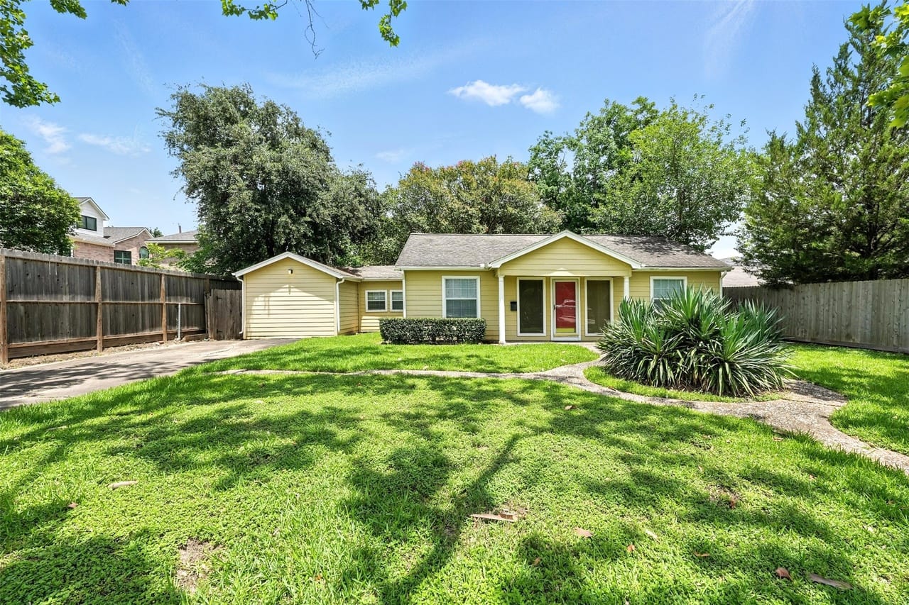
The houses on Oakdale street sit close to the ground. No stairs lead to their doors. In the early 1950s, a man returning from the Pacific or Europe could walk from the sidewalk to his front door without climbing a single step. Nobody engineered against the earth.
The alignment between house and ground assumed something so basic it went unspoken: that the ground itself was stable, that the environment could be lived with rather than defended against. That assumption would not survive the next seventy years.
Bellaire, Texas was barely a place before the war. In 1940 it held 1,124 people—a post office, some ambition, and a lot of flat coastal prairie. By 1950 it held 10,173. Developers were putting up 600 to 700 homes a year, and the town was simultaneously a construction site and a functioning city. The streets were unfinished. Cars dodged potholes deep enough to damage steering knuckles. Open stormwater ditches ran alongside every block, and homeowners crossed them on small bridges to reach their driveways. The suburb was being assembled, lot by lot, out of flat land and collective ambition, by systems that nobody owned individually but everyone depended on.
Marketing materials called it the "City of Homes." The target audience was the Midwestern farmer and the returning veteran who wanted something after years of nothing. "Good Air," the brochures said, though the air in Houston in August is anything but.
The men who filled these homes were engineers and geologists and administrative managers at Humble Oil, Shell, and Texaco. Humble was the largest domestic crude producer in the country, and its steadiness was the neighborhood's steadiness. These were not wealthy men. They were upwardly mobile and structurally secure, which in the 1950s was an entirely sufficient thing to be. The wages were steady. The benefits covered illness and vacation. The house did not need to make them rich. It was not yet an investment. It was not yet a form of protection. It was simply a place to live.
The houses themselves were modest by every standard except the one that mattered: they were owned. Roughly 1,200 to 1,400 square feet, two bedrooms, one bath, kitchen and dining combined. Cedar shake siding, oak parquet floors, asphalt shingles, slab-on-grade foundation. Ads called out "FHA FINANCED" in capital letters, because the mechanism of ownership was as important as the ownership itself. For a veteran using the GI Bill, the down payment could be zero. "Hardwood floors throughout," the ads continued. "1 block from shopping center." Proximity was local and specific. Nobody was measuring the commute to downtown.
The social world was organized by proximity. On summer evenings the yards were full—children on the grass, neighbors visible from the sidewalk, voices carrying across the open lots. Life happened in public by default. The front yard was a kind of commons, and the street was its organizing spine. Nobody had to decide to be social. Distance hadn't yet made it optional.
However, as I’ve written before, this life was not available to everyone. Deed restrictions in Bellaire's original covenants specified "Caucasian race only," barring Black, Jewish, and Asian residents from ownership. The schools were segregated, and when Brown v. Board arrived in 1954, Houston's school district found ways not to comply; a federal court eventually described the district's desegregation plan as a "sham and subterfuge." Classified ads listed household workers by race, slotting Black women into positions in homes they could not purchase. The stability of this neighborhood was constructed and enforced, and it depended on exclusion.
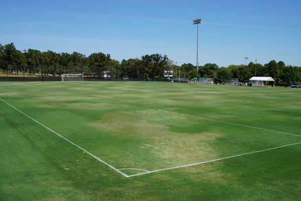
Governance reflected the same impulse. In 1955, residents voted on whether to allow any rezoning toward commercial use: 3,616 against, 779 for. The suburb actively defended itself. But what it could not defend against was Loop 610. The freeway was adopted in 1954, cut directly through Bellaire, removed 190 to 250 homes, and left a 350-foot corridor across the city's body. About 50 residents showed up to a council meeting to protest. Their concerns were dismissed.
The system was not local. The interstate highway program, funded federally and executed at the state level, overrode municipal preference. Bellaire could vote on zoning, but not on the path of a freeway. The same federal apparatus that had enabled suburban growth through mortgages and infrastructure now cut through it according to a different logic—mobility over locality.
The house held a life. That was its purpose and, for a generation, it was sufficient. But the conditions that made it sufficient were not permanent features of the world. They were a particular arrangement, already being quietly revised. What happened next was already latent in the logic of the place: the land was worth something, and eventually the market would say so.
When the House Became Strategy
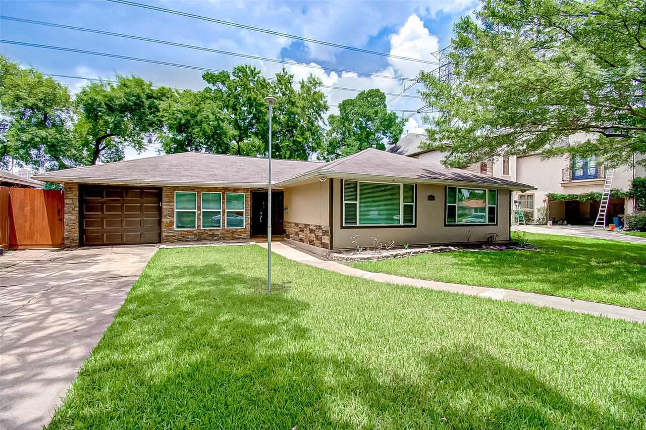
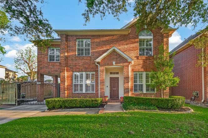
Walk down Oakdale street in the late 1990s and something is off. The lots are the same—8,000 to 10,000 square feet, the original grid intact. But some houses are twice the size of their neighbors. Second stories have appeared where there were none. The scale is discontinuous in a way that isn't gradual. These houses didn't grow. The old ones were removed and different ones were built in their place. What the 1950s had understood as permanence turns out, in retrospect, to have been a price point.
The population had been falling since 1960, when Bellaire peaked at 19,872 residents. By 1990 it had dropped to 13,842. The original housing stock was aging. The civic model worked financially when the homes held their value. When they stopped, the model frayed. What looked like a neighborhood in decline was actually a neighborhood whose land had outgrown its structures.
The mechanism was simple. As Bellaire's proximity to the Texas Medical Center and the Galleria increased in value, and as Bellaire High School became one of the most sought-after public school assignments in the city, the land under the old cottages appreciated faster than the cottages themselves. A lot might be worth $350,000. The house on it might add $50,000 to that number. When land reaches 70 or 80 percent of total property value, the structure becomes an obstacle. Developers call this Highest and Best Use. The 1950s house had become, in the cold vocabulary of real estate, debris—material to be cleared in order to unlock the value of the dirt beneath it. Bellaire liberalized its zoning in the late 1980s and early 1990s as a recognition of what was already happening. By 2008, roughly 47 percent of the housing stock had been rebuilt since 1993. Half the houses on any given street were, structurally, different houses than had stood there before.
The math of replacement was straightforward. Buy the lot for $400,000. Demolish the cottage. Build a house that sells for $1.2 million or more. The rule of thumb was roughly three times the land cost. When the market supported that multiple, the old house had no future. On Oakdale, a 1950s cottage of about 1,300 square feet gave way in 1997 to a new house of nearly 4,000 square feet. Same land, radically different structure.
The buyers who came for these houses were not the buyers of the 1950s. Doctors affiliated with the Medical Center. Lawyers at downtown firms. Energy executives. Dual-income households who chose Bellaire for its school zoning, proximity to work, and resale trajectory. A 1999 build on Oakdale that sold for around $300,000 would be worth over $900,000 by 2026. Even after adjusting for inflation, the home represents a doubling in ‘real’ value. Where the postwar resident had wanted somewhere to live, the 1990s buyer wanted somewhere that would appreciate. The neighborhood had become a sorting mechanism, and it selected accordingly.
The mechanism had changed, but the structure had not. The 1950s sorted by race through explicit exclusion. The 1990s sorted by class through price. Both produced the same outcome: a controlled population, defined by who could access the neighborhood under the prevailing rules of entry.
The houses expanded to match. Two stories became standard. Footprints grew to 3,000 or 5,000 square feet. Inside: commercial-grade ranges, wood-paneled studies, wine rooms, open-plan living areas designed for a kind of social performance categorically different from sitting on a porch.
The yard shrank to margins—and then shrank further. The city had rules limiting how much of a lot a house and its driveway could cover, meant to preserve some open ground for drainage. Builders got around them by using gravel or gapped paving stones, arguing that because water could technically seep through, those surfaces didn't count. The city eventually closed the loophole, but the fight itself said something: the question was no longer what a neighborhood should look like. It was how much house you could fit on a lot before the city stopped you.
Central air made the extraction possible. Pre-AC construction in Houston required windows that caught the southeast breeze, high ceilings to lift rising heat, layouts one room deep so cross-ventilation worked. Central air made none of that necessary. The 4,000-square-foot house, its windows sealed and its interior rooms with no natural ventilation, simply ignored the climate. That indifference had a consequence nobody was tracking.
A natural prairie absorbs rainfall slowly, with a runoff coefficient of roughly 0.15—meaning that eight and a half inches out of every ten sink into the ground. A concrete roof or driveway rejects almost everything. When a giant house replaces a yard, the water that once moved through grass and low spots now hits impervious surface and arrives at the street in seconds. The old lots had low depressions in their backyards that held water during storms. When builders raised the building pads with structural fill, they eliminated that storage. The water they displaced went to the adjacent lot, to the street, and to the bayou downstream.
The social world was changing too, though more quietly. The 1950s evenings of open yards and audible neighbors gave way to fenced backyards and closed garages, life retreating behind the canopy the maturing trees now provided. The scale of the new houses changed the relationship to the sidewalk—more massing, less invitation. The distance between a resident and the street grew.
What was happening on Oakdale was climate transformation. The replacement of porous ground with impervious surface, the expansion of structures, and the elimination of informal drainage space were hydrological changes. They altered how water moved through the neighborhood, how quickly it accumulated, and where it went.
The system still appeared stable because the underlying risk had not yet been realized. But the conditions were being set. The neighborhood was becoming more valuable and, at the same time, more exposed. The transformation of the land was underway, but it was not yet legible as risk. What was legible was that the arrangement was working. Values were rising. The schools were excellent. Everything was being priced except the ground itself—and the ground was quietly changing in ways that no one had yet put a number on.
When the House Became a Hedge
Hurricane Harvey arrived in late August 2017 and did not leave for four days. In Bellaire, approximately 1,936 homes flooded—roughly 29 percent of the city. About 2,300 (around 35%) sustained structural damage. Of all the homes in the city, approximately 47—two percent—had been built to the standards the city would eventually require. Harvey did not just flood houses. It measured the distance between what the city had built and what the sky was now capable of delivering.
The city had been warned before. Tropical Storm Allison in 2001 had already shown what a stalled system could do—dropping more than 30 inches of rain in places and flooding thousands of homes across the region. The pattern repeated in the years that followed. The Memorial Day flood of 2015, the Tax Day flood of 2016, and Hurricane Harvey in 2017 each exceeded what statisticians had classified as a 500-year flood—an event with a 0.2 percent annual probability. Three such events in such close succession reflected a deeper problem: the underlying maps had been drawn for a different atmosphere. In 2018, the National Oceanic and Atmospheric Administration (NOAA) released updated rainfall frequency data under the Atlas 14 project, which revealed that what had been classified as 500-year events were occurring at intervals consistent with 100-year probabilities. The old 500-year floodplain was the new 100-year floodplain.
This shift was because of climate change. Warmer air holds more water vapor—roughly 7 percent more for every degree Celsius of warming. On the Gulf Coast, that extra moisture is increasingly released in sudden, intense bursts rather than steady rain. Storms are also moving more slowly than they once did, a pattern researchers have linked to changes in atmospheric circulation caused by the same warming. The result is storm systems that do not pass through Bellaire so much as park over it, unloading days of rain onto ground that has nowhere left to put it.
Additionally, the 1990s development had made it easier to flood with less rain than the original models assumed. The flood was not only a product of the atmosphere. It was also a product of the neighborhood.
The city rewrote its standards. The 100-year Base Flood Elevation was replaced by a new Design Flood Elevation: the 500-year floodplain plus one additional foot of freeboard. Every new structure had to meet it. Every substantially damaged structure had to meet it. Substantial damage meant repair costs exceeding 50 percent of the structure's pre-flood market value.
This is where the 1950s house finally ran out of time. The market value of an original Bellaire cottage had been compressed for decades by the high value of the land beneath it. A house the market valued at $50,000 as a structure—sitting on a lot worth $400,000—crossed the 50 percent threshold with $25,000 in flood damage. At that point, the owner was legally required to bring the entire structure into compliance: elevation, at a cost of $100,000 to $300,000, applied to a structure worth $50,000. The federal flood program's compliance provision covered a maximum of $30,000. The gap could only be bridged with private capital. The 50 percent rule was technically a building code requirement. Its practical effect was a filter.
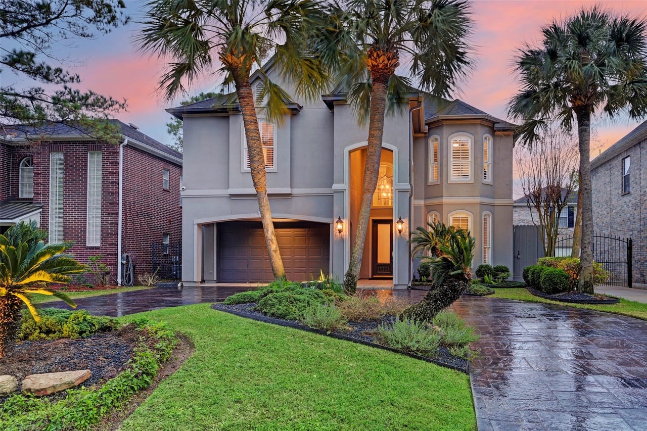
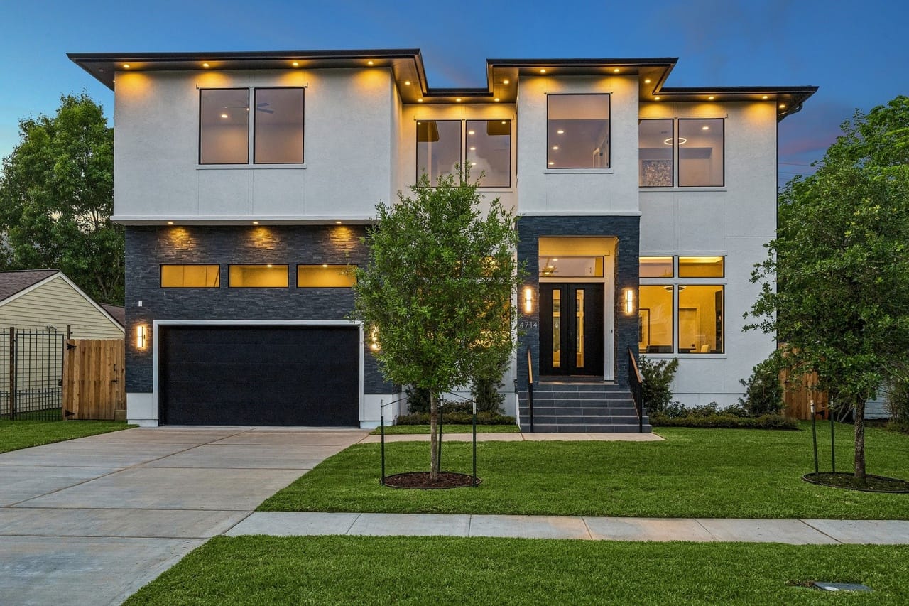
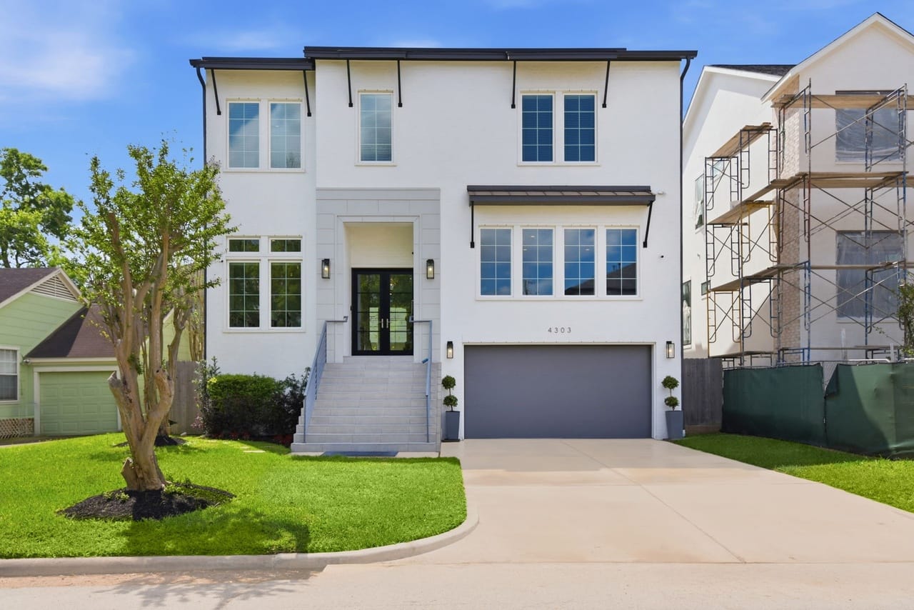
What emerged on the other side of that filter looked different from anything before it. The slab-on-grade foundation was replaced by pier-and-post construction. The house sits above the ground on an elevated platform. Stairs lead to the front door. Mechanical systems are mounted above the flood elevation. The entire structure encodes a calculation: the ground will fail, and the house must be positioned to survive it. Stylistically, the elevated houses trended toward stucco and Mediterranean forms, grand entry staircases giving them a vertical emphasis the 1950s cottages never had. The house that once met the street at grade now stands above it, looking down.
The staircase carried a cost that did not appear in flood models. For elderly residents or those using wheelchairs, the elevated house introduced a daily barrier. What had once been a single step from sidewalk to door became a vertical threshold. Adaptation made the house safer against water, but less accessible to the bodies that lived inside it.
Real estate listings found language for the new environment. "Never Flooded!" appeared as a selling point, its exclamation mark carrying exactly the anxiety it was meant to dispel. "Not in flood zone per seller" transferred actuarial uncertainty politely from seller to buyer. "DFE compliant" signaled to buyers who knew what DFE meant—and increasingly they did. The luxury markers remained alongside flood certifications: Sub-Zero appliances, grand foyers, wine rooms. Risk had become a feature, listed with the kitchen specifications, because the buyer needed to know about both.
What had once been flood exposure—geographically shared, falling more or less equally on the neighborhood—became financially stratified. Harvey sent the same water across the whole block. What it produced was not the same outcome. The elevated house, built after Harvey to current standards, sustained minimal damage. The older house at grade, owned by a family that lacked the capital to comply, faced a choice between selling and spending money they didn't have on a structure worth less than the cost of the work. The 50 percent rule, technically neutral, set a capital threshold that sorted who could remain. Multiplied across hundreds of properties, the same storm became two different events—a manageable setback for those with liquidity, and a forced exit for those without it. Adaptation, it turned out, was not protection. It was a good, and access to it was priced.
The function had shifted before the form did: the 1990s house was a strategy, organized around the assumption that the future was improvable. The post-Harvey house was organized around a different premise—that loss was probable, and the task was to survive it. Everything about it, from its height to its listing language to its insurance structure, was designed to limit damage. The suburb was being reprogrammed, lot by lot, for a future the original builders had not modeled and the 1990s buyers had not priced.
The Meaning of the Street
Stand on Oakdale street now and look at what is actually there.
One house sits close to the ground, a slab-on-grade cottage from the early 1950s, hardwood floors inside, a carport to one side, a yard that runs down to the street without interruption. Next to it a house from the late 1990s sits on the same lot size at three times the square footage, its brick facade occupying ground where a yard once was, its second story rising above the original roofline of everything around it. Down the block, a 2025 build stands on a pier-and-post foundation, its front door reached by a wide staircase, its entrance now higher than the person standing on the sidewalk. Three houses. Three ideas about what the future is going to do.
The 1950s house says the future is continuous with the present. You meet the ground at grade because the ground can be trusted. The 1990s house says the future is better than the present—taller, larger, worth more. You extract from the land because the land rewards extraction. The post-Harvey house says the future is hostile. You elevate because the ground will flood, and surviving that flood is what the house is for.
Each of these beliefs was legible to its moment. The 1950s belief held as long as the climate was stable and the economic arrangements were intact. The 1990s belief held as long as appreciation outran exposure. Harvey ended the second belief without fully discrediting it—values in Bellaire continued rising after 2017—but it made the third belief unavoidable. The elevated house is a structure that has priced in catastrophe and is prepared to weather it. That is different, in kind, from a house that assumes the weather will be manageable.
The street holds all three beliefs simultaneously. Climate change does not arrive as a single transformation. It arrives as a pressure that exposes what was already there. Harvey revealed what Bellaire had always been: low-lying, built on former prairie, in a warming atmosphere, made more exposed by the same development that made it more valuable.
What it also revealed was who the vulnerability belonged to. The three houses on this block receive the same rain. The water does not distinguish between the cottage and the elevated build, between the owner with capital and the one without. But the outcomes diverge. Protection follows the money—as it does at every scale, across every form of climate exposure. The homeowner who can afford to elevate stays. The one who can’t faces a forced exit encoded in a building code provision.
Bellaire is wealthier than it has ever been. The house that sold for $9,000 in 1952 (the equivalent of about $112,000 in 2026 dollars) is worth $1.5 million or more now. Flood probability over a 30-year mortgage is estimated above 90 percent. These facts coexist without canceling each other because the capacity to manage risk is itself a form of wealth—and what looks like resilience, at the neighborhood scale, is often replacement. The families who absorbed the loss and sold were replaced by families who could afford to build above it. The street looks continuous. The population is not.
What looks stable on this street is engineered survival. The canopy is full. The houses are handsome. Order has been maintained. But the order is purchased, and it selects for who can afford to maintain it. Managing the future now requires something the 1950s house never asked of anyone: a continuous, expensive, technically sophisticated effort to stay ahead of what the ground and sky are likely to do. The people who cannot sustain that effort do not get to stay on the street.
They move further out—to older subdivisions east of the loop, to unincorporated Harris County, to neighborhoods that have not yet been rebuilt and may never be, where the housing stock is cheaper, the ground sits lower, and the drainage infrastructure was designed for a different century. They don’t leave the flood zone. They move deeper into it. The risk the elevated house shed is transferred, along with the people who couldn't afford to stay, to ground that was already more exposed and is now more crowded.
Bellaire got safer. The water went somewhere else.